5:52am on a Tuesday, and the only people at the Dajia Riverside Park entrance near Yuanshan MRT are a man doing tai chi with a small portable speaker playing erhu music, two women walking backwards (this is a thing here, and they're faster than you'd expect), and you. The asphalt is still cool. The Keelung River smells faintly of mud and overnight rain. Taipei 101 is barely visible through the haze to the south, and the only sounds are your shoes on the path and the low hum of the Zhongshan Bridge overhead.
This is what running in Taipei actually feels like when you find the right route at the right time. Not fighting scooters on Zhongxiao East Road. Not doing laps around your apartment block. The city has over 100 kilometers of riverside bike paths, a handful of excellent park loops, and mountain trails 15 minutes from the nearest MRT station. Most of them have water, most of them have shade, and almost none of them require you to cross a single intersection.
Here are seven routes I keep coming back to, with the details you actually need before lacing up.
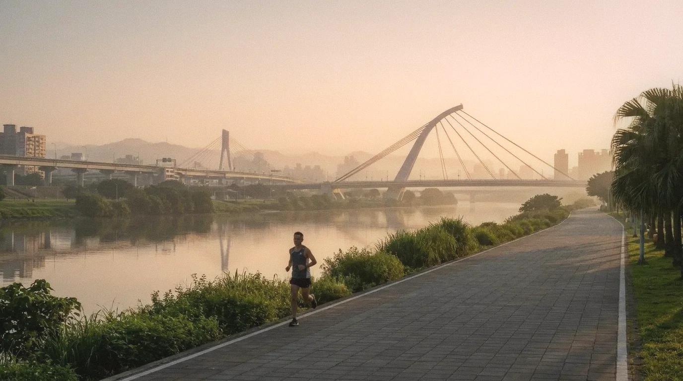
1. Dajia Riverside Park to Rainbow Bridge (and back)
Distance: 6.5 km one way, 13 km round trip. Surface: Paved asphalt bike path. Water: Drinking fountains at Dajia Park entrance and near Raohe Street Night Market end. Vending machines roughly every 2 km along the path. Access: Yuanshan MRT (exit 1, walk 5 minutes to riverside entrance) or Songshan MRT (exit 3 toward Rainbow Bridge).
This is the workhorse route. The path follows the south bank of the Keelung River from the Dajia Riverside Park all the way east to the Rainbow Bridge near Raohe Night Market. It's flat, wide, well-lit even before dawn, and long enough to build real mileage without repeating yourself.
The first 3 km from Dajia are the prettiest. You pass the park's massive water fountain area (it runs on the hour during the day, but at 6am it's just a quiet open field), the Dazhi Bridge underpass with its surprisingly decent mural work, and a long stretch where the path narrows slightly and the trees lean in from both sides. On weekday mornings, you'll share the path with maybe a dozen cyclists and a few other runners. Weekends get busier after 7am.
The Rainbow Bridge end deposits you essentially at the back door of Raohe Night Market, which is closed in the morning but makes for an excellent post-run reward if you time it for an evening session instead. The 胡椒餅 vendor near the temple entrance opens around 4pm.
2. Da'an Forest Park Loop
Distance: 2.4 km (perimeter sidewalk), 1.5 km (internal red gravel track). Surface: Concrete sidewalk (perimeter) or red gravel (inner track). Water: Multiple drinking fountains inside the park, especially near the amphitheater and the ecology pond. Access: Da'an Forest Park MRT (exit 5 puts you right at the park edge).
If the riverside is for long runs, Da'an is for short ones done well. The 2.4 km perimeter loop on the wide sidewalks surrounding the park is smooth, shaded by camphor and banyan trees, and marked with distance indicators every 100 meters. Inside the park, there's a 1.5 km red gravel track that's easier on your knees and popular with the morning crowd.
You can do five perimeter laps and call it a 12 km day, or mix perimeter laps with the interior track for variety. The park is at its best between 6 and 7am, when the tai chi groups are out, the air still smells like wet leaves instead of exhaust, and the path is mostly clear. By 8am, strollers and dog walkers take over. By 9am on weekends, forget it.
The practical advantage of Da'an is that it's centrally located and the MRT station is directly adjacent. If you live anywhere along the Xinyi or Tamsui lines, you can be running within 30 minutes of leaving your apartment. I used this route for speed work, doing 400-meter intervals using the distance markers on the perimeter path. It's not glamorous, but it's precise and convenient, and on most mornings that matters more than scenery.
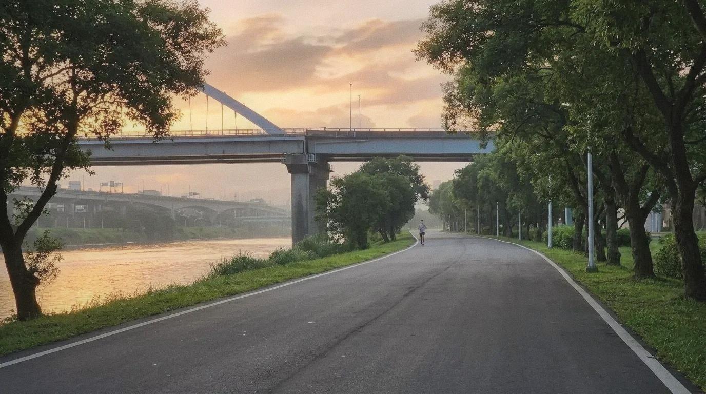
3. Keelung River Right Bank: Nangang to Neihu
Distance: 17.6 km (full right bank path), or 8-10 km for the Nangang-to-Neihu segment. Surface: Paved bike path. Water: Drinking fountains at Nangang and Neihu riverside park entrances. Convenience stores accessible via ramp exits roughly every 3 km. Access: Nangang MRT or Kunyang MRT (both have riverside park access within 10 minutes walking).
The right bank of the Keelung River gets less attention than the left bank, and that's exactly why I like it. The path is equally well-maintained but noticeably less crowded, especially the stretch between Nangang and the Neihu Technology Park area. On a weekday morning, you might go 3 km without seeing another runner.
The scenery is more industrial than the Dajia route. You'll pass under highway overpasses, alongside recycling plants, past a few construction sites that seem to never finish. But there's something honest about it. The Keelung River is wider here, and during morning golden hour, the light bouncing off the water and the steel bridge supports makes the whole thing look like someone applied a filter to an unglamorous place. Which is, if I'm being honest, what I like about most of Taipei.
This is a good route for zone 2 training. Flat, uninterrupted, and boring enough that you can actually hold a conversation with yourself about pace without getting distracted. Bring your own water for anything over 8 km, though. The fountain spacing on this side is less reliable.
4. Xinyi District "Runseeing" Loop
Distance: Roughly 4 km (flexible, depending on your route through the district). Surface: Sidewalks and pedestrian plazas. Water: 7-Elevens and FamilyMarts on essentially every block. Access: Taipei City Hall MRT (exit 2) or Xiangshan MRT.
If you're staying in a hotel near Taipei 101 or Xinyi, this is the route that makes the most of what's around you. Start at Sun Yat-sen Memorial Hall, loop through the wide pedestrian promenade around the memorial (the grounds alone give you a good 1.5 km loop), then head east along Songzhi Road past Taipei City Hall and into the Xinyi shopping district.
Early morning Xinyi is a completely different place from evening Xinyi. The malls are closed, the LED screens are off, and the wide pedestrian plazas between the department stores become surprisingly pleasant running surfaces. You can loop past the base of Taipei 101, cut through the Xinyi Public Assembly Hall park, and circle back to the memorial. The whole thing is roughly 4 km with zero elevation change and total convenience store coverage for water.
It's not wilderness. It's not even particularly scenic beyond the 101 views. But it's convenient, it's safe, and it solves the "I'm in a hotel and I don't want to run on a treadmill" problem completely.
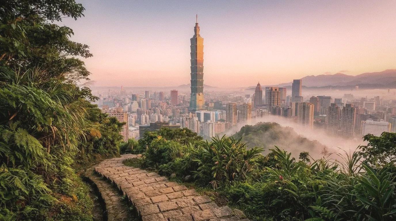
5. Elephant Mountain Trail (Xiangshan)
Distance: Roughly 1.5 km to the summit, 3 km round trip (with extensions along the Four Beasts Mountain ridgeline up to 8+ km). Surface: Stone steps and packed-earth trail. Water: No water on the trail itself. Fill up at the 7-Eleven near the Xiangshan MRT trailhead (exit 2, turn right, walk 3 minutes). Elevation: 183 meters to the summit. Access: Xiangshan MRT (exit 2).
This is not a flat jog. Elephant Mountain is a straight-up stair climb, roughly 600 stone steps from the trailhead to the main viewing platform at the Six Boulders lookout. Trail runners love it for exactly this reason. The elevation gain in such a short distance makes it an efficient quad and cardio workout, and the payoff at the top is one of the most photographed views of Taipei 101 you'll find anywhere.
The smart move is to combine this with a Xinyi District warm-up. Run the 2 km from Sun Yat-sen Memorial Hall to the trailhead, climb the mountain, take in the view (you've earned it), and descend. Total distance around 7 km with significant elevation. Best done before 7am to avoid the tourist and selfie crowd at the top. By 8am on weekends, the Six Boulders platform is standing room only.
For the ambitious: the trail continues along the Four Beasts Mountain ridgeline (Elephant, Lion, Tiger, Leopard mountains), and you can extend the run to 8 km or more if you follow the full connected trail system. The terrain gets rougher and less crowded the further you go.
6. Jingmei Riverside Path
Distance: 3.8 km (left bank) or 8.1 km (right bank), combinable for a 12 km loop using bridge crossings. Surface: Paved bike path. Water: Vending machines along the path accept EasyCard. Restrooms with wash stations roughly every 2 km. Access: Gongguan MRT (exit 1, walk to Jingfu Bike Rental Station at the riverside entrance) or Jingmei MRT.
The Jingmei River is the underrated pick. It starts near Gongguan, which means you can combine it with a campus run through NTU if you want (the university grounds add another 3 km of shaded paths), and it extends all the way south toward Muzha and the Taipei Zoo area.
What makes Jingmei different from the Keelung River routes is the feel. The path is narrower, the trees are closer, and the development along the banks is lower-rise. In sections, it genuinely feels like you're not in the middle of a city of 2.6 million people. The stretch between the Yongfu Bridge and Jingmei Bridge, roughly 4 km along the right bank, is my favorite running segment in all of Taipei. At 6am, the mist sits low over the water and the only company is the occasional egret standing completely still in the shallows, looking like it has absolutely nothing on its schedule.
The vending machines along this route take EasyCard, which means you can run without cash or a phone if you just bring your transit card. A bottle of water costs NT$20, and there's usually a machine within sight.
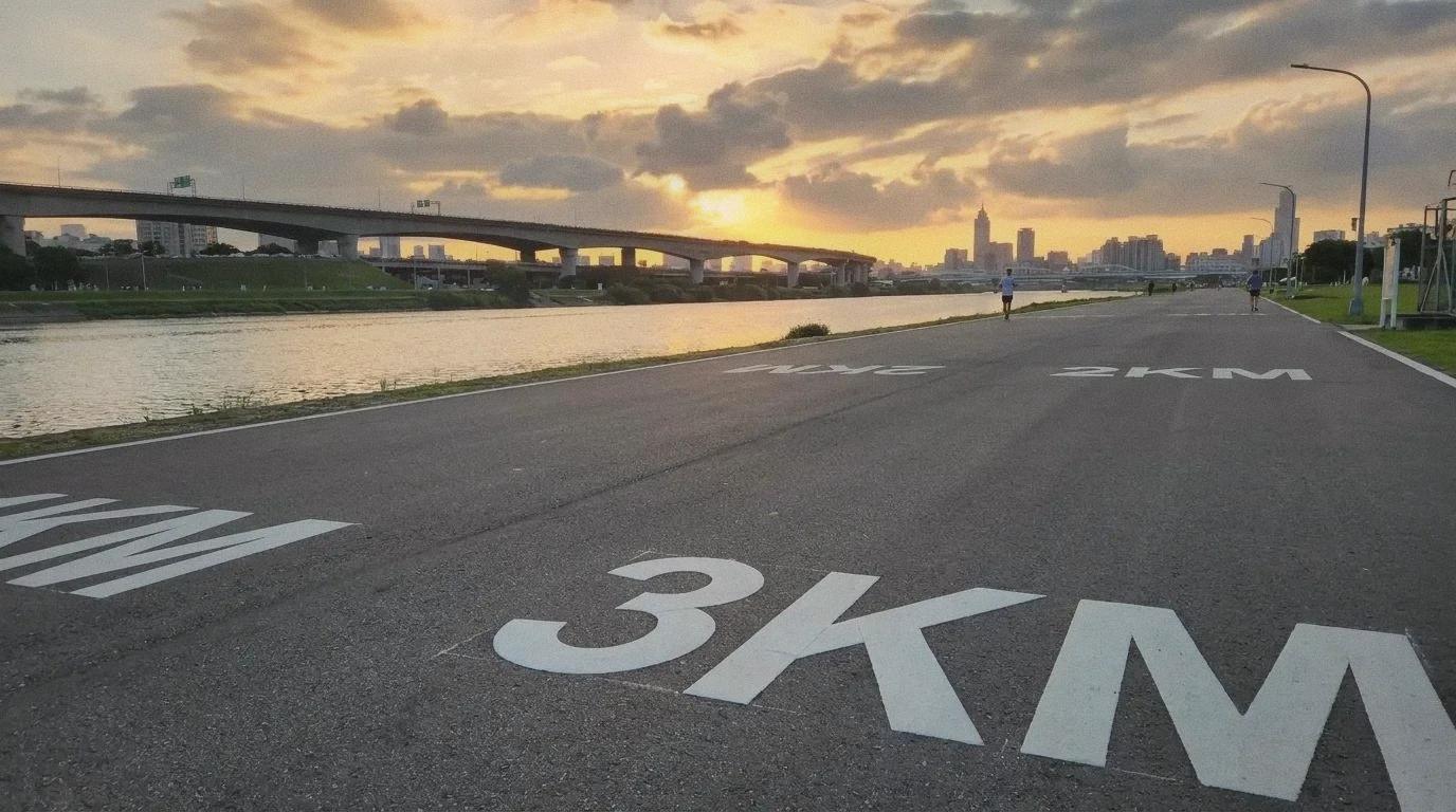
7. The Taipei Marathon Course (Training Route)
Distance: 42.195 km (full marathon), but you can run the most scenic 10 km segment: City Hall to Nangang Exhibition Center along the Keelung River. Surface: City streets (race day) / riverside path (training adaptation). Water: Convenience stores along Renai Road, plus riverside park fountains once you hit the Keelung River section. Access: Taipei City Hall MRT (the marathon start/finish area).
You don't have to be training for the marathon to use this route. The Taipei Marathon course, which starts and finishes near Taipei City Hall, follows a loop through Zhongzheng District, up Zhongshan Road, across the Keelung River, and along the riverside paths east to Nangang before returning.
The best training segment is the 10 km stretch from City Hall east along the south bank of the Keelung River to the turnaround near Nangang Exhibition Center. It's essentially a section of Route 1 (Dajia Riverside) but approached from the Xinyi side, which changes the feel. You start urban, transition to riverside, and hit a clean turnaround point. The standard Taipei Marathon is held every December, so if you're thinking about registering, running this segment regularly gives you a taste of race-day terrain.
Practical notes for running in Taipei
Heat. May through September, anything after 8am is a sauna. The humidity regularly hits 80-90%, and even at 6am the temperature can sit at 28°C. Hydrate before you leave. Carry water for anything over 5 km. Accept that your pace will be slower than whatever you're used to in drier climates. Roughly 10-15% slower is normal and not a sign that you're losing fitness.
YouBike rescue. Every major riverside path has YouBike 2.0 stations at the entry/exit ramps. If you bonk, twist an ankle, or just run out of motivation at the far end of a route, you can rent a bike for NT$5 per 30 minutes with your EasyCard and pedal back. This is the safety net that makes longer riverside routes less intimidating. I've used it twice. Both times I was grateful.
Timing. The best window is 5:30 to 7am, year-round. It's cooler, quieter, and the light is worth waking up for. Evening runs (after 6pm in summer, after 5pm in winter) are the second-best option. The riverside paths have lighting, though some sections between Nangang and Neihu are dimmer than others.
Rain. It rains a lot, especially November through March. The riverside paths drain well and are perfectly runnable in light rain. Heavy rain can flood low-lying sections near river access ramps. Check the weather, carry a hat with a brim, and accept that you'll get wet. Running in warm Taipei rain is actually not bad once you stop trying to avoid it.
FAQ
Do I need to register or pay to use the riverside paths? No. All riverside bike paths and parks in Taipei are free and open to the public. No registration, no fees. Just show up.
Are the paths safe for solo runners early in the morning? Yes. The main riverside routes (Keelung River, Jingmei River, Dajia Park area) are well-lit and regularly patrolled. I've run solo at 5:30am hundreds of times without any safety concerns. Use normal common sense, and you'll be fine.
Can I run on the bike paths or will cyclists get annoyed? The paths are designated for both cyclists and pedestrians. Stay to the right, be aware of faster cyclists approaching from behind, and you'll have no issues. The paths are wide enough for both. Some sections have separate lanes marked for bikes and pedestrians.
Where do I store my stuff while running? Most runners here carry minimal gear. A phone, an EasyCard, maybe some cash. MRT station lockers (NT$20-50) are available at major stations near trailheads. For riverside runs, I just bring my transit card in a small wrist pouch and leave everything else at home.
What shoes work best for Taipei running? Road shoes for all the riverside and park routes. Trail shoes only if you're doing Elephant Mountain or the Four Beasts ridgeline. The stone steps on Xiangshan are slippery when wet, so good tread matters there. The flat paths are all smooth asphalt or concrete.
Comments (0)
Loading comments...